The Disaster Center's Hurricane Debby Page
Hurricane

Infra Red
---- MPG Movie

Visible
---- MPG Movie

Water Vapor
---- MPG Movie
Public Advisory  Forecast/Advisory     Discussion   Maps/Charts   Wind Probs
Index
___________________
1. State
2. Local Governments and Sheriff's Offices
3. Local EM
4. Evacuation and Evacuees
5. Shelters
6. Federal
7. International
8. Preparedness
9. Tracking
10. Flooding
11. Shoreline
12. Satellite and Radar
13. Environmental
14. Health Affects
15. Damage Assessment
16. Discussion Board: questions, suggestions, and reports.
17. Year 2006 Hurricane Debby Diary
Tropical Storm Debby
IR


WindMariner's Water vapor Gulf of MexicoWind Speed Warnings andPuerto Rico
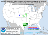
August 27, 2006 -- The current theory is that a category  3 Hurricane Ernesto will hit Florida.
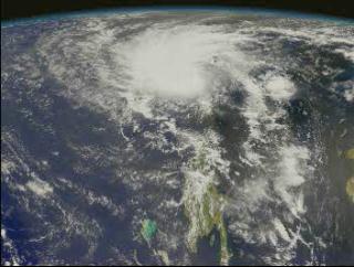
August 27, 2006 -- Debby barely a tropical cyclone... At 500 AM AST the center of Tropical Depression Debby was located near latitude 28.6 north - longitude 49.3 west or about 1435 miles west-southwest of the Azores. The depression is moving toward the northwest near 13 mph and a turn toward the north is expected today. Maximum sustained winds are near 30 mph with higher gusts. Little change in strength is forecast during the next 24 hours and Debby could lose tropical characteristics today. The estimated minimum central pressure is (1012 mb) 29.88 inches.

(return to top of page)
Current Weather Watches                                 Watch, Warning and Advisory Display
Current Weather Watches map                           Watch, Warning and Advisory Display Map
Today's National
Forecast                            Current  Weather              National Weather Warnings
NOAA Current Watches/Warnings        Current Weather map          National Weather Warnings Map
Day 1 Forecast  Precipitation                                Day 2 Forecast Precipitation

       
 Day 1 Forecast Precipitation map                 Day 2 Forecast Precipitation map
The Rothstein Catalogue!
States
Massachusetts Emergency Management Agency
North Carolina Division of Emergency Management
South Carolina Emergency Preparedness Division
Virginia Department of Emergency Management
Maryland Emergency Management Agency
Delaware Emergency Management Agency
Texas Emergency Management Agency
Texas Emergency Management Situation Reports
Texas Weather Cameras
Florida Division of Emergency Management
Louisiana Office of Homeland Security and Emergency Preparedness
Mississippi Emergency Management Agency
Mississippi Forestry Commission -- Situation Reports
Arkansas Department of Emergency Management
The Oklahoma Department of Emergency Management
Alabama Emergency Management Agency
Georgia Office of Homeland Security - GEMA
Arkansas Department of Emergency Management
Tennessee Emergency Management Agency
VAEmergency.com Responding to Katrina
Traffic
Massachusetts Traffic Information
Alabama: Traffic Information Line: 1-800-843-0699
Florida: Emergency Information Line: 1-800-342-3557
Louisiana: Traffic Information Line: 1-800-256-7036
Mississippi: Traffic Information Line: 1-800-222-6362
Texas: Highway Conditions Information: 1-800-452-9292
(return to top of page)

Local Governments and Sheriff's Offices
Local Emergency Management Offices


Evacuation
FEMA tele-registration – 800.621.3362  (For Individuals)
Red Cross call center  - (Clothing, Food & Shelter & Contractors)2-1-1 or 888.317.4567
(in Texas only) or  800 HelpNow or 800 Get-Info (nationwide)
Salvation Army – 800 SAL-ARMY (800.725.2769)
FIND LOVED ONES
 American Red Cross         877.568.3317
www.familylinks.icrc.org or www.redcross.org
Find Family National Call Center           866.326.9393
Lost Children:      Children’s Assessment Center  713.986.3300

Google has a name based search engine that accesses databases of evacuees.
MCI's Registration service of evacuees.
Evacuees register themselves by calling  1-877-HELP-KAT (1-877-435-7528) Locate someone who is missing by calling 1-866-601-FIND (1-866-601-3463).
Scipionus.com - Information Locator Map -- Click on the map to find information posting related to a specific area
Search and Rescue, U.S. Coast Guard Requests for rescues of missing or stranded persons will be entered into the system, viewed by command center and prioritized as received.
National Next of Kin Registry
Salvation Army's Team Emergency Radio Network (SATERN) ActivatedSend an online request to locate missing family and friends. If you can't connect to the site immediately, please try again.
Red Cross Alert for Persons with Emergency Medical ConditionsThe Red Cross is only accepting phone calls to search for missing persons in these emergency circumstances: insulin dependant diabetics, oxygen dependant, dialysis patient, blind, recent heart attack or stroke victims, mobility challenged, broken leg, foot or ankle, or paralyzed.
National Next Of Kin Registry International Emergency Contact System
Missing Persons Board
Wal-Mart's Hurricane Katrina Message Board


(return to top of page)

Federal
Whitehouse -- Katrina In Focus
National Hurricane Center
FEMA
FEMA - Press
FEMA Emergency Managers Reports
FEMA - Photo Library
National Park Service  - Morning Report
The U.S. Army Corps of Engineers
Hurricane Katrina Response; Environmental Protection Agency
  (return to top of page)
HHS - Disasters and Emergencies: Hurricane Katrina
SAMHSA's Disaster Mental Health Resource Kit  1-800-789-2647 for bilingual information services (1-866-889-2647: TDD) Monday through Friday, 8:30 a.m. to 5 p.m. EST.
National Incident Management Situation Report by NICC -- PFD
Dept. of Transportation -- Highway Information For Areas Affected By Hurricane Katrina - US ...
US Army Corps of Engineers - Katrina Response
US Coast Guard - Storm Watch
Navy Environmental Health Center --Medical Force Protection for Hurricane Katrina Relief  Situation Reports
Hurricane Katrina's Impact on U.S. Energy
Office of Energy Assurance: Hurricane Katrina Situation Reports
Advisory Situation Reports from The HSUS Disaster Center
Disaster Contractors Network Situation Reports
(return to top of page)

International
Assessing progress towards disaster risk reduction within the context of the Hyogo Framework
Reliefweb International
The Caribbean Disaster Emergency Response Agency
(return to top of page)

Recovering From and Coping With Flood Damaged Property after Returning Home
The Disaster Assistance Process for Individuals

Preparedness
A FEMA Guide to Hurricane Preparedness
US Fire Administration -- Hurricane and Tornado Fire Safety Factsheet HSUS and FEMA --
FEMA Agaist the Wind: Protecting Your Home from Hurricane and Wind Damage -- PDF
FEMA After a Flood: The First Steps
Standard Family Disaster Plan. 
Why Talk About Hurricanes?
Community Hurricane Preparedness. 
(return to top of page)

Animals
Animals and Emergencies
(return to top of page)

Tracking
Hurricane Tracking Chart 
Color Hurricane Tracking Chart 
Map Hurricane Risk in United States 
The Hurricane FAQ
(return to top of page)

Mitigation
Hurricane Damage to Residential Structures: Risk and Mitigation
Designing for wind speed map 
The Saffir-Simpson Scale  Insurance Q and A 
Education Hurricanes - CotF
If you have any Questions, Comments or suggestions please send an email to:
Host@disastercenter.com
Google
 
Flooding
Massachusetts Real-Time Water Data
Arkansas Real-Time Water Data
Florida Real-Time Water Data 
Louisiana Real-Time Water Data
Texas Real-Time Water Data
Make an Online Hazard Map for Your Location
National Data Buoy Center
NOS WATER LEVEL OBSERVATION NETWORK
NWS River Forecast Information
NWS Flash Flood Guidance
NWS Significant River Flood Outlook USGS Current Water Resources Conditions
nowCOAST: GIS Mapping Portal to Real-Time Environmental Observations and NOAA Forecasts
National Flood Insurance Program
National Weather Service Precipitation Analysis
National Weather Service (NWS) River Forecast Centers
(return to top of page)

Satellites and Radar
NOAA GOES Satellite Imagery for Tropical Sectors
NOAA Multi-Dimensional Imagery from Polar Orbiting and Geostationary Satellites
Naval Research Laboratory (NRL) Monterey Marine Meteorology Division Tropical Cyclone Information
NASA MODIS Rapid Response System
NWS National Doppler Radar Sites  
NASA - Latest Hurricane News
NASA - Multimedia Features
NASA - Hurricane Resource Reel
(return to top of page)

Track Analysis/Best Track
National Hurricane Center/Tropical Predictions Center Archive of Past Hurricane Seasons
Historical Hurricane Tracks
Continental US Landfall of Hurricanes 1950 - 2004
(return to top of page)

Shoreline Change
United States Geological Survey (USGS) Coastal and Marine Geology Program Internet Map Server
USGS Hurricane and Extreme Storm Impact Studies
USGS Mapping Coastal Change Hazards
NOAA Coastal Services Center Topographic Data
(return to top of page)

Environmental Affects
NOAA Office of Response and Restoration
(return to top of page)

Health Affects
Morbidity and Mortality Weekly Reports
For the CDC index on hurricane information (including fact sheets in English and other languages), please see: 
CDC"s Hurricane Index
For CDC information specific to healthcare professionals
Hurricane-Related Documents and Resources Recently Released or Updated
Drive Safely
http://www.bt.cdc.gov/disasters/pdf/flyer-drive-safely.pdf
Returning Home After a Hurricane: Be Healthy and Safe
http://www.bt.cdc.gov/disasters/hurricanes/returnhome.asp
Cleaning and Sanitizing With Bleach after an Emergency
http://www.bt.cdc.gov/disasters/bleach.asp
Varicella Info from NIP
http://www.cdc.gov/nip/diseases/varicella/
Addition of Safe Water Tips to Announcer Read PSAs
http://www.bt.cdc.gov/disasters/hurricanes/psa_announcerreads.asp#rita
Disposal of Contaminated Medical Devices – FDA site
http://www.fda.gov/cdrh/emergency/disposal.html
Contact Information for Questions about Clinical Investigations Affected by Hurricane Katrina – FDA site
http://www.fda.gov/cder/emergency/clin_invest.htm  
Carbon Monoxide Poisoning After Hurricane Katrina --- Alabama, Louisiana, and Mississippi, August--September 2005 – MMWR Article
http://www.cdc.gov/mmwr/preview/mmwrhtml/mm54e930a1.htm
 
The following documents have been recently UPDATED:
Effects of Hurricane Katrina on Children's Blood Lead Levels
http://www.bt.cdc.gov/disasters/hurricanes/katrina/leadkatrina.asp

Translations for the following documents are now available: (return to top of page)


Damage Assessment and Post-Storm Impact Data

(return to top of page)

Other sites

The Hurricane Watch Net
HurricaneTrack.com
Caribbean Hurricane Network
Hurricane Strike! Hurricane Science & Safety For Students
DURING A HURRICANE WATCH
(A Hurricane Watch is issued when there is a threat of hurricane conditions within 24-36 hours.)
1. Listen to a battery-operated radio or television for hurricane progress reports.
2. Check emergency supply kit.
3. Fuel car.
4. Bring in outdoor objects such as lawn furniture, toys, and garden tools and anchor objects that cannot be brought inside.
5. Secure buildings by closing and boarding up windows. Remove outside antennas.
6. Turn refrigerator and freezer to coldest settings. Open only when absolutely necessary and close quickly.
7. Store drinking water in clean bathtubs, jugs, bottles, and cooking utensils.
8. Store valuables and personal papers in a waterproof container on the highest level of your home. 9. Review evacuation plan.
10. Moor boat securely or move it to a designated safe place. Use rope or chain to secure boat to trailer. Use tiedowns to anchor trailer to the ground or house.
Source: floridadisaster.org/      Florida's Division of Emergency Management
(return to top of page)


Year 2006 Hurricane Debby Diary
August 26, 2006 -- Debby barely hanging on as a tropical depression and could dissipate on Sunday.  At 1100 PM AST the center of Tropical Depression Debby was located near latitude 27.9 north - longitude 48.5 west or about 1425 miles west-southwest of the Azores. The depression is moving toward the north-northwest near 12 mph and a turn to the north-northeast is expected during the next 24 hours. Maximum sustained winds are near 30 mph with higher gusts. Little change in strength is forecast during the next 24 hours...but Debby could degenerate to a remnant low on Sunday. Estimated minimum central pressure is (1012 mb) 29.88 inches.
August 26, 2006 -- Debby moving northwestward over open waters... At 500 PM AST the center of Tropical Depression Debby was located near latitude 27.0 north - longitude 47.5 west or about 1410 miles west-southwest of the Azores. The depression is moving toward the north-northwest near 12 mph. A turn to the north is expected during the next 24 hours. Maximum sustained winds are near 30 mph with higher gusts. Little change in strength is forecast during the next 24 hours. Estimated minimum central pressure is (1009 mb) 29.80 inches.  (1009 mb) 29.80 inches.
August 26, 2006 -- Debby continues to struggle over the open waters of the eastern Atlantic.  At 1100 AM AST the center of Tropical Depression Debby was located near latitude 25.6 north - longitude 47.3 west or about 1465 miles west-southwest of the Azores. The depression is moving toward the west-northwest near 8 mph. A turn to the northwest is expected later today. Maximum sustained winds are near 30 mph, with higher gusts. Little change in strength is forecast during the next 24 hours. Estimated minimum central pressure is
August 26, 2006 -- Debby weakens into a depression.  At 500 AM AST the center of Tropical Depression Debby was located near latitude 25.3 north - longitude 46.7 west or about 1450 miles west-southwest of the Azores. The depression is moving toward the west-northwest near 13 mph. A turn to the northwest is expected later today. Maximum sustained winds are near 35 mph with higher gusts. Little change in strength is forecast during the next 24 hours. The estimated minimum central pressure is (1009 mb) 29.80 inches.
August 25, 2006 -- At 1100 PM AST the center of Tropical Storm Debby was located near latitude 25.2 north - longitude 45.6 west or about 1400 miles southwest of the Azores.  Debby barely hanging on as a tropical storm.   Debby is moving toward the west-northwest near 14 mph, and a turn to the northwest and then north-northwest is expected over the next 24 hours. Maximum sustained winds are near 40 mph with higher gusts. Little change in strength is forecast during the next 24 hours. Tropical storm force winds extend outward up to 105 miles  from the center. Estimated minimum central pressure is (1008 mb) 29.77 inches.
August 25, 2006 -- Debby continues moving west-northwestward over open waters.  At 500 pm ast the center of Tropical Storm Debby was located near latitude 24.9 north - longitude 44.7 west or about 1470 miles west-northwest of the Cape Verde Islands. Debby is moving toward the northwest near 17 mph and this motion is expected to continue during the next 24 hours. Maximum sustained winds are near 40 mph with higher gusts. Little change in strength is forecast during the next 24 hours. Tropical storm force winds extend outward up to 50 miles  from the center. Estimated minimum central pressure is (1003 mb) 29.62 inches. 
August 25, 2006 -- Debby weakening over open waters.  At 1100 am ast the center of Tropical Storm Debby was located near latitude 23.9 north x longitude 43.3 west or about 1365 miles west-northwest of the Cape Verde Islands. Debby is moving toward the northwest near 17 mph, and this motion is expected to continue during the next 24 hours. Maximum sustained winds are near 40 mph, with higher gusts. No significant change in strength is forecast during the next 24 hours. Tropical storm force winds extend outward up to 50 miles...85 km from the center. Estimated minimum central pressure is (1003 mb) 29.62 inches.
August 25, 2006 -- Debby expected to remain over open waters.  At 500 AM AST the center of Tropical Storm Debby was located near latitude 22.9 north - longitude 42.3 west or about 1285 miles west-northwest of the Cape Verde Islands. Debby is moving toward the west-northwest near 17 mph  And this motion is expected to continue during the next 24 hours. Maximum sustained winds are near 50 mph with higher gusts. No significant change in strength is forecast during the next 24 hours. Tropical storm force winds extend outward up to 50 miles from the center. Estimated minimum central pressure is (1000 mb) 29.53 inches.
August 24, 2006 -- Debby continues west-northwestward over the open waters of the eastern Atlantic. At 1100 PM AST the center of Tropical Storm Debby was located near latitude 21.9 north - longitude 41.1 west or about 1190 miles west-northwest of the Cape Verde Islands. Debby is moving toward the west-northwest near 18 mph, and this general motion is expected to continue during the next 24 hours. Maximum sustained winds are near 50 mph with higher gusts. Little change in strength is forecast during the next 24 hours. Tropical storm force winds extend outward up to 50 miles from the center. Estimated minimum central pressure is (1000 mb) 29.53 inches.
August 24, 2006 -- At 500 PM AST the center of Tropical Storm Debby was located near latitude 21.3 north -- longitude 39.5 west or about 1080 miles west-northwest of the Cape Verde Islands.  Over the next few days Debby is expected to curve towards the north, through the central Atlantic.  Debby is currently moving toward the west-northwest at near 20 mph, and this motion is expected to continue over the next 24 hours. Maximum sustained winds are near 50 mph with higher gusts. Little change in strength is forecast during the next 24 hours. Tropical storm force winds extend outward up to 60 miles  from the center. Estimated minimum central pressure is (1000 mb) 29.53 inches.
August 24, 2006 -- . Debby is no threat to land.  At 1100 am ast the center of tropical storm debby was located near latitude 20.4 north -- longitude 37.8 west or about 955 miles west-northwest of the cape verde islands. Debby is moving toward the west-northwest near 20 mph, and this motion is expected to continue for the next 24 hours. Maximum sustained winds are near 50 mph with higher gusts. Some slow strengthening is possible during the next 24 hours. Tropical storm force winds extend outward up to 60 miles from the center. Estimated minimum central pressure is (1000 mb) 29.53 inches.
August 24, 2006 -- Debby expected to remain out to sea.  At 500 AM AST the center of Tropical Storm Debby was located near latitude 19.6 north...longitude 36.3 west or about 845 miles west-northwest of the Cape Verde Islands. Debby is moving toward the west-northwest near 20 mph, and this general motion is expected to continue for the next day or so. Maximum sustained winds are near 45 mph, with higher gusts. Slow strengthening is forecast during the next 24 hours. Tropical storm force winds extend outward up to 50 miles...85 km from the center. The estimated minimum central pressure is (1003 mb) 29.62 inches
August 23, 2006 -- Debby getting better organized again over the eastern Atlantic.  At 1100 PM AST the center of Tropical Storm Debby was located near latitude 18.8 north - longitude 34.7 west or about 730 miles, west-northwest of the Cape Verde Islands. Debby is moving toward the west-northwest near 18 mph, and a west-northwest to northwest motion is expected over the next 24 hours. Maximum sustained winds are near 45 mph with higher gusts. Some slight strengthening is possible during the next 24 hours. Tropical storm force winds extend outward up to 50 miles  from the center. The estimated minimum central pressure is (1003 mb) 29.62 inches.
August 23. 2006 -- Debby loses some organization as it moves northwestward.  At 500 PM AST the center of Tropical Storm Debby was located near latitude 17.9 north...longitude 33.0 west or about 610 miles west-northwest of the Cape Verde Islands. Debby is moving toward the northwest near 20 mph and a west-northwest to northwest motion is expected over the next 24 hours. Maximum sustained winds are near 45 mph with higher gusts. Little change in strength is forecast during the next 24 hours. Tropical storm force winds extend outward up to 50 miles  from the center. Estimated minimum central pressure is (1002 mb) 29.59 inches
August 23, 2006 -- Debby is slowly gathering strength over the far eastern Atlantic.  At 1100 AM AST the center of Tropical Storm Debby was located near latitude 16.8 north -- longitude 31.5 west or about 500 miles west of the Cape Verde Islands. Debby is moving toward the west-northwest near 17 mph, and this motion is expected to continue for the next 24 hours. Maximum sustained winds are near 50 mph with higher gusts.  Tropical storm force winds extend outward up to 50 miles...85 km from the center. Estimated minimum central pressure is (1000 mb) 29.53 inches.  It appears, at this time, that Debby will not be striking North America.
August 22, 2006 -- Tropical Depression Four strengthens into the fourth tropical storm of the season over the far eastern Atlantic Ocean. At 1100 PM AST.  The center of Tropical Storm Debby was located near latitude 15.2 north...longitude 28.9 west or about 300 miles west of the southernmost Cape Verde Islands. Debby is moving toward the west-northwest near 18 mph  And this general motion is expected to continue for the next 24 hours. Maximum sustained winds are near 40 mph with higher gusts. Some strengthening is forecast during the next 24 hours. Tropical storm force winds extend outward up to 45 miles  from the center. The estimated minimum central pressure is (1003 mb) 29.62 inches.
 August 21, 2006 -- At 5 PM AST the government of the Cape Verde Islands has issued a tropical storm warning for the Cape Verde Islands. This Storm is likely to become Hurricane Debby.
  • The Disaster Center's Year 2000 Hurricane Message Board Page 
  • The Disaster Center's Year 1999 Hurricane Message Board Page 
  • The Disaster Center's Year 1998 Hurricane Message board 
  • The Disaster Center's Year 2000 Hurricane Index Page 
  • Why Talk About Hurricanes? 
  • The "Standard" Family Disaster Plan 
  • National Hurricane Center 
  • Hurricane Tracking Chart 
  • Color Hurricane Tracking Chart 
  • Caribbean Hurricane Network 
  • NOAA Hurricanes Natures Greatest Storms 
  • THE Hurricanes FAQ 
  • Hurricanes: The Basics 
  • Broward Florida's -- Hurricane Prep. Fact Sheets 
  • NOAA Hurricane/Tropical Storm Warnings 
  • Tropical Discussions: Atlantic Hurricane Center 
  • Tropical Outlook: Atlantic Hurricane Center 
  • Aircraft Reconnaissance Current Observation 
  • The Hurricane Watch Net
  • Hurricane Watch Net E-mail Updates
  • Lowe's Hurricane Central: E-mail Updates 
  • CNN's Hurricane E-mail Updates 
  • NRL Monterey Marine Meteorology Division (Code 7500) Tropical Cyclone Page 
  • Atlantic Sea Surface Temperature Analisis 
  • Atlantic Sea Surface Temperature Anomaly 
  • CDC NCEH Hurricane A Prevention Guide to Promote Your Personal Health and Safety 
  • Spanish - CDC NCEH Huracán A Prevention Guide to Promote Your Personal Health and Safety 
  • Canadian Hurricane Centre 
  • Weather Sites 
  • Map Hurricane Risk in United States 
  • Hurricane Damage to Residential Structures 
  • NOAA PHOTO Library - Weather -- Hurricanes 
  • NOAA : Hurricanes - Nature's Greatest Storms 
  • Tropical Cyclone FAQ 
  • How Safe is Your Home? 
  • Insurance: Hurricane season '97 
  • NOAA AOML - Hurricane Research Division 
  • Designing for wind speed map 
  • The Saffir-Simpson Scale 
  • Insurance Q and A 
  • Insurance: After the water recedes 
  • Education Hurricanes - CotF
  • Hurricane Science for Kids 
  • NOAA's Aircraft Operations Center 
  • MEMA/FEMA Hurricane Preparedness 
  • Dr. Gray's Seasonal Hurricane Forecast 
  • Flood damage Information 
  • Floods 
  • Hurricane Q and A 
  • FEMA mitigation - Hurricanes 
  • FEMA - Facts About Hurricanes 
  • FEMA - Fact Sheet: Hurricanes 
  • FEMA Tropical Storm / Hurricane Info. 
  • Hurricane Hunters - 53 WRS 
  • Hurricane Animation sequences 
  • Miami-Dade Building Product Control 
  • Sourcebook on Economic Losses - Hurricane 

  • Debby Tracking Map
    Debby Satellite Images
    Hurricane Debby advances on the U.S..
    1.1 MB MPEG Movie Hurricane Debby
    From our Year 2000 Hurricane Debby Diary --
    The worst thing is: when a forecast of danger is made, and nothing happens. Because, if everyone is wrong, where do we place our trust?

    For a while Debby fooled everyone. And we should ask ourselves, and those who we depend on us should ask, how is it that we were wrong?

    What happened that caused us to make such a great mistake? What, if anything, did we learn? And what should we do to acknowledge the mistake?

    We are fortunate to have an association with a forecaster who is above mincing words:

    Folks
    After looking over all the data over the past week with regard to Debby... it seems clear to me that the winner and still champion of the forecast world -- as it relates to the Debby Fiasco -- is the ECMWF.

    The ECMWF was frequently dismissed in various forms by many forecasters both private and govt. The European consistently weakened Debby and sheared it apart. In fact it NEVER --not once - developed or intensified Debby. Moreover the ECMWF'S 's position of shoving Debby to the WSW into Cuba along with the weakening the system was by far and away the best model performance there was.

    Over the last several years with regard to the tropics the ECMWF has never failed. I know this is going to seem like a extreme statement to many but it is factually accurate. It performed the best in 99 with Floyd by as far out as 6 days a Landfall NOT over Florida but eastern NC and VA (which is what occurred). It was the first model to show Dennis would stall off the east coast for 3 days. And it was the ONLY model that showed Bonnie in 1998 would pass over Norfolk VA 60 hrs before landfall-- when the official track placed it just over Cape Hatteras then turned her sharply out to sea.

    Anyway getting back to Debby... the ECMWF appeared not to pick (initialize) Debby well and I, like many others, the ECMWF solution skeptically. But it was there staring us in the face and we dismissed it out of hand. And the southern track of the NOGAPS was also consistent and its reputation as a decent tropical model was also disregarded.

    Moreover another lesson learned is this: From Day 9 (that is AUG. 15) the MRF consistently showed a large strong tropical system (i.e. Hurricane) on OR just off the East coast of the US. Both runs of the MRF (00z and 12z) as well as the 12z AVNx offered this solution with out any deviancy from Aug. 15 00z to 8/22 without fail.

    Therefore IF Debby had become a decent size/strength cane and had affected Florida and the east coast then it would mean the OPMRF was right and a better tropical model than the ECMWF. It would show or demonstrate the OPMRF has skill.

    No freaking way.

    Disregarding TPC's statement of undeserved praise it showered on the MRF (and ignoring the 8 "false alarm" tropical cyclones the model has developed since July 1) ... Not on the MRF's best day is has that model ever depicted better solutions than the ones posed by the ECMWF and NOGAPS. I cannot recall one instance in the last 10-12 years where the MRF forecast development and track of a tropical system has been close to be considered a "hit". Perhaps it has happened but I cannot recall.

    The clear loser here is besides the MRF is the GFDL .. which has performed unbelievably badly. Fantasy Category 4 hurricanes and turns to the North.

    Just my opinion. But I hold that the MRF's day after day drum beat that there was going to be a big event on or off the east coast built in a bias that colored a lot of forecasters thinking. There may have been a underpinning towards looking for a turn to the north and significant intensification... because of the MRF.

    DH Tolleris

    wxrisk.com

    PS Today's AVNX (Aug. 26) is spinning up ANOTHER tropical storm off the Florida coast in 96 hrs. That can be seen here:
    http://sgi62.wwb.noaa.gov:8080/STATS/maps/avn/latest/f96.gif
    My advice is not to hold your breath....

    The name Debby was first used in 1982

    In 1982 Hurricane Debby was a named Storm from the 13th - 20th of September.  The Storms maximum winds: 115  Knots with a minimum pressure of: 950.  Hurricane Debby was a catergory 4 Hurricane the formed off the coast of Hati, but did not strike land.

    In 1988 Hurricane Debby was active from the 31st of August - 8th of September.   The Storms maximum winds: 65 Knots with a minimum pressure of: 987.  Debby formed in the Gulf of Mexico and struck the coast of Mexico south of Tampico.
     
    In 2000 Hurricane Debby was a named Storm from the 19th - 24th of August   The Storms maximum winds: 65 Knots with a minimum pressure of: 995 MB .  Debby formed in the Atlantic and passed through the Virgin Islands, Puerto Rico, Haiti, the Dominican Republic and Cuba before disapating at sea.
     

    The States Pages
    New ---- on States Pages --- Current Weather information links to over 600 NOAA Weather Stations

    Disasters by Design :

    A Reassessment of Natural Hazards in the United States by Dennis S. Mileti
    Our Price: $47.95


    Model 74-200 SAME Weather/All-Hazard Radio
    List Price: $99.95 -- Our Price: $69.99 -- You Save: $29.96


  • Click here to add this page to your favorites